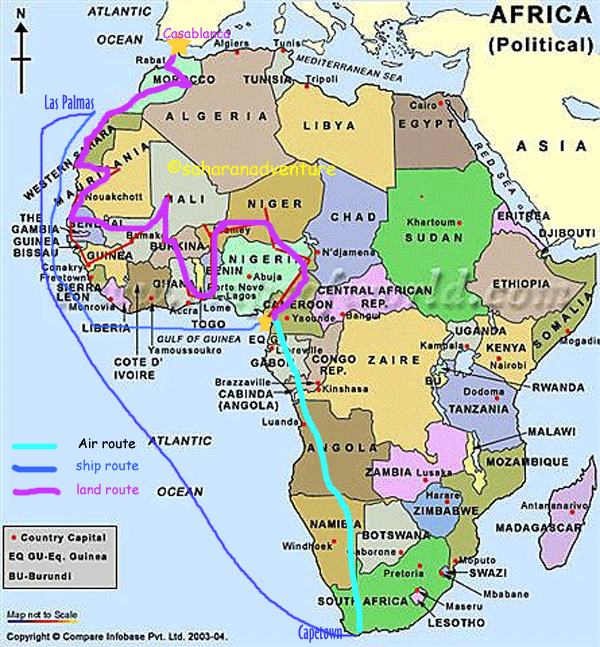
Cameroon to Morocco
*******************************************************************************
Cameroon- 2007 facts from Lonely Planet:
Area: Smaller than Spain, bigger than California
ATM's available at banks in large cities
Budget: $40.00 per day (!)
Capital: Yaoundé
Money: CFA ($1.00= CFA498)
Population: 16.4 million
Seasons: hot year round: north: wet (April to Sept); south: heavy rain from June to October with November to February the best to visit, except harmattan (sand storm)haze most of the time.
Tel: country code 237, international access code 00
Visas: required by all, available in neighboring countries for $60.00
Cameroon is often described as the "Melting Pot of Africa" due to huge diversity of people (272 ethnic groups), the contrasts in climate (10 times as much rain on coast as in the interior), geography (lush rainforests in south and near-desert in north), language (officially English but French is spoken too as well as 160 African dialects) and religion (Catholic/Protestant south and Muslim north with traditional African religions everywhere).
Highlights:
MOUNT CAMEROON: West Africa's highest peak (4095 meters). Difficult hike as per altitude change. 2 night/3 day trek packages available.
KRIBI: Cameroon's most popular beach resort. Crowded on weekends but sleepy during the week. No ATM machines. Camping is not advised. Most hotels have own beachfront and cost $32.00-50.00 per night. There may be an undertow and riptide so ask before you swim.
RING ROAD: circular 367km route through the heart of Cameroon's northwestern highlands best known as the Grassfields. Ask local chief before camping. Very scenic with rolling hills, mountains, lakes and waterfalls and traditional kingdoms. There is nowhere to change money so stock up on CFA.
MANDARA MOUNTAINS: This is about trekking from village to village enjoying the scenery…area is rich in tribal culture (Tourou village where the ladies where calabash hats: Maga village with unique domed houses made entirely of clay; Mora village with its notable weekly market. Its possible to drive between most villages which extend to Nigerian border.
PARC NATIONAL DE WASA: Most accessible of Cameroon's parks and best for viewing wildlife. Elephants, hippos, giraffes, antelope and possibly lion. Particularly rich bird life. A 4x4 is necessary and a guide (CFA3, 000) in each vehicle is obligatory. Camping available outside the park entrance.
NOTE: Transparency International consistently ranks Cameroon as one of the world's most corrupt countries. This is every aspect of daily life from dealings with petty gov't officials to the rampant destruction of the rainforests by the logging interests and kickbacks from the recently completed oil pipeline from Chad to Kribi.
Traditional social structures dominate life. Local chiefs hold power and visitors must get chief's permission to enter tribal lands…gift of bottle of whiskey is customary. Chiefs called "fon" in the west and "lamido" in the north.
Most Cameroonians are involved in agriculture. Major regional exporter of food.
Cameroonians love football and drinking beer. Football is national obsession.
Arts include ceramics, highly detailed bronze and brass work and wood carving esp. masks of animals (believed the wearer of the mask can assume the animal's powers)
The staple dish is a starch such as rice or fufu (yams, corn, plantain or couscous mashed) with a peppery sauce on it. A very popular sauce is ndole (a bitter leaf like spinach, flavored with smoked fish). Grilled meat and fish are eaten heavily along with plenty of fruit.
YAOUNDE: Population of 1.1 million. Unique among West African capitals for its green and hilly setting. Its altitude of 750m makes it less humid and less hectic than Douala so it's a good place to rest and apply for onward visas. There are ATMs at banks but travelers checks are a problem.
DOUALA: This is the economic powerhouse of the country. "A sweltering hot mess of dusty honking traffic jams". Good restaurants, lively nightlife and decaying tropical ambiance. Bad reputation for muggings. "Yaoundé sleeps Douala rocks". Express Exchange will change traveler's checks and US dollars. Recommended Supermarkets= (good prices and both located in Akwa district) Mahima Supermache on Bd du President Ahmadou Ahidjo or Onashi Supermarche on 421 Rue Alfred Saker. There is a Score Supermarche and Unimarche near Rue Tokoto but they are pricy imports from Europe.RECOMMENDED TEXTILE SHOP = Boutique Cicam/ 712 Boulevard du President Ahmadou Ahidjo. Great selection and prices. Musee de Douala Mon-Fri 8-2:00PM Marche Central (or Marche de Lagos) located south of Ave Douala Manga Bell, is Cameroon's largest market….traditional meds, fruit & veggies are in Marche de Kassalfam. Our Hotel is called La Procure Generale des Missions Catholiques on Rue Franquerville, Akwa. The mission is a good value but often full. Facilities include a swimming pool. Rooms are clean and have AC and a shower room. The supermarkets are located in this district as well as many recommended restaurants many of which offer cheap Greek, French, German and Cameroonian dishes.
SOUTH WEST PROVINCE
LIMBE: Easygoing port is the centre of English Cameroons. Best known as a weekend getaway from Douala and its fresh seafood. A visit to Limbe Wildlife centre is exception to the usual WA zoos. It is internationally renowned (TV series) and is one of only 20 primate sanctuaries in the world. It contains rescued primates (many are bushmeat orphans) in large enclosures and staff are heavily involved in community education and local conservation. Limbe also has a Botanical Garden which is very jacked up with guided tours and a jungle village featured with cultural activities offered, an adventure trail and bar/restaurant. There are nice beaches bordered by tropical vegetation west of town. The fine sand is dark brown due to ancient lava flow from Mount Cameroon. Beaches featured in the film Chocolat. Parc Hotel Miramar has camp sites /chalets. Camping on the public beaches is not recommended for security reasons.
MT. CAMEROON= this is the highest Mountain in North Africa and 6th highest in Africa. It's an occasionally active volcano with its base at ocean floor and summit lost in the clouds it's still easy to climb (much less strenuous than Kilimanjaro). The mountainsides are covered in rainforest and there are many trails to ascend to the top. A guide is compulsory and the climb averages 3 days return.
KUMBA= Largest town of South West Province it's 138km north of Douala and considered to be one of Cameroon's most beautiful regions with Barombi Mbo, a stunning crater lake with crystal clear waters. Measuring 2.5 km across and 100 meters deep, the lake is overwhelmingly peaceful. The town has the look and feel of the American Wild West. There is fabulous birding at nearby Mount Kupe National Park, 45 km east of Kumba.
KORUP NATIONAL PARK= this is Africa's oldest remaining rainforest…estimated at more than 60 million years and is the most accessible forest of its type in Cameroon. The forest is home to more than 1,000 known species. WWF has a conservation project here. It's possible to hike with guide.
WEST PROVINCE This area is known for its central highlands…volcanic crater lakes, dense vegetation, rolling hills, spectacular waterfalls. Paved roads lined with coffee and cocoa plantations. Rich in culture of ancient chiefdoms.
BAFANG= the town itself is nothing special but the surrounding scenery is beautiful….series of waterfalls some of which are 30m high.
BANDJOUN= Largest of the Bamileke chiefdoms it contains one of the most impressive traditionally built palaces in West and Central Africa. The chefferie is open to visitors and has a small museum.
FOUMBAN: Predominantly Muslim, this is the first place you will hear the call to prayer if you are driving north. Centre of Cameroonian handicrafts. See the Palace Royal (Sultans palace) currently home to the 19th sultan of the Bamoun dynasty. It may be possible to meet him as he strolls in the foyer on Fridays during the morning and after prayers at around 13.00. Musicians entertain him while subjects wearing strikingly flowing robes and with long brass trumpets meet with him. A traditional Bamoun dance, mbansie, is performed. Palace has a great museum. Bilingual guides available. South of town is the Village des artisans which has more handicrafts than the rest of the country combined. Each of the houses set in rows into the village contains a workshop, with craftspeople sculpting, carving, basket weaving, embroidering and beating metals. Market days are Saturday and Wednesday. There is an Annual Tabaski Festival/horse race/parade to celebrate the end of Ramadan.
NORTHWEST PROVINCE This Anglophone region has cool climate, hilly terrain and is best known for the Ring Road which navigates the mountainous Grassfields.
BAMENDA= Bamenda is the district capital and is the heart of the English-speaking opposition movement against the French-speaking dominance in Cameroun. Riots and demonstrations in recent years but things seem quiet now..Ring Road begins here.
BAFUT= Bafut is a traditional Tikar chiefdom which was put on the map by Gerald Durrell in his 1950s book The Bafat Beagles. An established 700 year old kingdom the fon's wives are the tour guides for the palace which includes the giant 300 year old drum called "Nighaa Ni Bifh" used to send messages as well as ancient stones where enemies were put to death. Many colourful festivals held in this area with music and dancing. There is a 4 day festival just before Christmas with masks, dancing, music. In the market, every eighth day, a Durrell character, Pter Shu, The King of the Snakes, does a performance with mambas, cobras, pythons and vipers.
Lake Nyos= Known best for the fact that in 1986, mysterious natural gasses erupted from the lake in a cloud and killed over 1800 local villagers. The lake is still under investigation.
ADAMAWA PROVINCE This area is savanna and forest, thinly populated, mostly cattle farms and a handful of poor roads.
NGAOUNDERE=Dominated by the Palais du Lamido where he still resides with his many wives. Tours daily. Friday, Sat, Sunday the Lamido leads a procession of notables to the mosque, all dressed in colorful costumes. The tall conical "witches hat" thatched roof mud huts are scattered throughout this region. In times of war, the children were hidden under these roofs.
BANYO AND TIBATI= sleepy towns
NORTH PROVINCE This area is vastly different with its scarce vegetation, blistering harsh temperatures, totally Islamic Culture and archaic and primitive villages.
GAROUA= Very little here to attract tourists.
EXTREME NORTH PROVINCE This area is hot and dry with exotic villages, Cameroun's best national park, Wasa, and the spectacular Mandara Mountains.
MAROUA= located at base of Mandara Mountains and near Wasa Reserve.
MORA= Attractive little village with one of the best markets in Cameroun held each Sunday. Food stuffs and crafts. Open-air barbers, blacksmiths with hand bellows, local doctors selling traditional medicines. Refreshingly little of the garish plastic junk seen in south.
_____________________________________________________________
Country area = one-and-one-half the size of France
Population = 140 million people…largest population in Africa. (4% of the world's entire population) Nigeria has one of the lowest levels of modern family planning use in the world and a very high fertility rate. 40% of the population is under the age of 14. An average Muslim trader might have over 20 children (several wives).
Ethnic Groups = over 250 ethnic groups each with their own language and distinct cultural heritage and allegiance.
Language = English is the official language and is taught in schools and spoken with varying fluency by 50% of the population. Nigerian/English pidgin is understood throughout the country. Hausa, Yoruba, Igbo, Edo, Efik are major local languages.
ATMS= None; Bring only US dollar to Nigeria. Traveler's checks are useless. AVOID USING CREDIT CARDS DUE TO FRAUD.
Currency = Naira (N); $1 = N128 Budget = $25 to $45 per day
Capital = Abuja
Religion = Christian south and Muslim north except for small communities throughout who live as Muslims in south and as Christians in north creating religious unrest and recently violence. There are traditional religions and Juju, native magic, which is the basis for Caribbean voodoo and in markets it is possible to see charms and potions for sale.
Sharia Law = To Muslims, Sharia law is a God-given code for how life ought to be lived. The entire area of Nigeria that we will travel through is under Sharia Law since 2000. Punishment is harsh and quick (stoning to death for any woman adulterer and 100 lashes for sex outside of marriage.) We may see men and boys missing hands (first theft is the right hand; second theft is the left foot.) The dispute within Nigeria concerning Sharia law has created mammoth tension. ALCOHOL IS BANNED BY SHIRA LAW FOR ALL CONSUMPTION. If a Muslim is caught with alcohol, it is 80 lashes. Non-Muslims is N50000 fine and/or up to one year in Nigerian prison !!!!!
Government = British colonial rule until 1960 followed by civil war, military coups, oil boom in 1970's, corruption; in 2007 President Umaru Musa Yar' Adua took office.
Environment = 95% of Nigeria's forests have been logged and virtually no land is protected. Oil industry has created huge environmental problems with spills and gas flaring. Has resulted in violence in south delta region by local people.
Food = Food is called "chop". Dishes are hot and peppery with meat sauce mopped up with cassava/pounded yams. National dish might be Isiewu (goat's head soup) with cows leg soup or jollof (peppery) rice with chicken as close seconds. Look for signs saying "Food is Ready" when you are hungry. Arts = Said to be unequalled anywhere in West Africa, esp. music and literature. ALCOHOL IS BANNED BY SHIRA LAW FOR ALL CONSUMPTION. If a Muslim is caught with alcohol, it is 80 lashes. Non-Muslims is N50000 fine and/or up to one year in Nigerian prison !!!!! Nigeria has a reputation for corruption, e-mail scams and ethnic violence. And yet it is challenging and exuberant…Africa in the raw.
HIGHLIGHTS IN THE NORTH WHERE WE ARE TRAVELING: We will enter Nigeria from Cameroun at BAMA. It is then a 2 ½ hour drive to Maiduguri .
Maiduguri = A blindingly hot and sandy city. Mosques are prolific with every hotel having one, so be careful not to intrude on the twice a day prayers in the open courtyards by hundreds of thousands of men. The indigenous Kanuri people with elaborate plaited hair and colorful scarves live here and we may see camels coming in from the Sahara. Not much else to see here unless we drive out to see Lake Chad or go to Sukur which is Nigeria's only World Heritage site. It's an ancient mountain stronghold village of perhaps 2,000 people and the village has fantastic views of the steep terraced valleys below. Village is accessed by 500 ancient stone steps from the school at Mydlau.
Kano= Oldest city in West Africa (founded around 1400 years ago). It was a major crossroads in trans-Saharan trade routes and from the middle ages, has been a centre for Islamic scholarship. The oldest section is surrounded by walls resembling a medieval town. Kano is known for its terrible air pollution. Kano is popular for its traditional arts and crafts; weaving, indigo cloth-dyeing, leatherwork. Kano's dye pits are still in use and some of the oldest in Africa and are privately owned by the same family for over 500 years. Manager will give a tour (expect to pay dash (tip) all around esp. for photos…have lots of small bills handy) the indigo hand-woven cloth is sold with patterns such as "zebra in the bush". The main market, called Kurmi Market, is in the old city centre and is one of the most colorful and exotic places in the Sahel. Its over 1000 years old. Watch where you step as rickety wooden street slats cover running drains several meters below. It's so huge and congested you can become easily lost unless you hire a guide.
Muslim ceremonies take place in Zaria, Katsina and Zano. They are called Durbar, or formal receptions, where the Hausa-Fulani wear suits of armor, helmets and red turbans. The Emir, Islamic Chief, resides in center in white whilst the cavalry are in blue. Parades, drumming and dancing. They are held in November or possibly in December.
Return to map ___________________________________________________________
In Niger, local people say "If you haven't come to Niger, you haven't visited Sahara at all".
Area = 5 times the size of UK
ATMS= none
Literacy= 19% for Nigerians age 15 and older
Health care= One doctor per 33,000 people
Capital = Niamey
Languages = French (official language) spoken by 20% of the population, Hausa, Djerma, Fulani, Tamashek
Currency= West African CFA franc; US$1= CFA 656
Population = 10.5 million
Seasons = hot & dry (Sep-June), wet (Jul-Aug)
Religion = Islam (90%), Christianity and animism (10%)
Government= Niger became independent from France in 1960. Current President, Mamadou Tandja, was elected in 1999 and again in 2004 (for another 5 year term) in an election considered free and fair. In 2005, as part of a World Bank reform program, Tandja was pressured into imposing a 19% VAT on basic food products such as millet flour, rice, tea, sugar, and milk. Nigerien people felt betrayed and riots and demonstrations resulted. The 2004 drought/famine worsened the situation. While the international community looked on, Tandja publicly denied his people were starving. Again, people were angry, feeling that he missed the opportunity to tell the world they needed long-term food aid as famines are no surprise and happen every few years in Niger. The rains of 2005 resulted in a slow recovery from this crisis.
Niger is a relatively flat country and is generally hot, dry, and dusty, which are the major determinants for where people settle and how they live. 85% of the population lives in rural areas growing millet/sorghum in the arid areas or rice along the river or raising goats, sheep, cattle and camels. Niger has some of the world's largest deposits of uranium in the northeast and it provides the greatest export revenue. Recently exploitable deposits of gold have been discovered and oil exploration has begun. The north is known for the Tenere Desert and Air Mountains and the south is dominated by the Niger River and resulting wetlands. Unfortunately, Niger's natural resources are insufficient to sustain the present population. Even with ¼ of children dying before the age of 5, Niger has one of the highest population growths in the world. This demographic threat is referred to as "the silent crisis". Nearly half the government's budget is derived from foreign donor resources and over 2/3 of the population live below the poverty line. The HIV/AIDS level was 50% among prostitutes in 2002. Recently, the government has been brokering deals for poverty reduction which include decentralizing decision making, privatizing at least 12 utilities and improving quality of health and education in rural areas. In 2003, Programme Special was created and over 1,000 classrooms, 1,000 health centres and 1,000 wells and boreholes were built. Unfortunately, the buildings are mere shells lacking equipment, supplies, books or adequately trained staff so the battle is still on. Yet with this said, there is a feeling of change for the better in Niger with NGO's who are helping to create opportunities for Nigeriens such as www.friendsofniger.org which was set up by ex-Peace Corps members.
Slavery = Slavery is part of Niger's history but still exists with approx 43,000 illegal slaves being held in Niger today. This is a remnant of the traditionally layered caste social system.
Beggars = Giving alms is considered one of the pillars of Islam. Unfortunately white people are often singled out by beggars because of our wealth. Remember that as little as 100CFA will buy a plate of rice/sauce and perhaps even some meat. Decide where you stand of giving to beggars and try to stick to it for your own sanity. You can also decide to give back in a more substantial way such as gifts to the village elders or to the school. The most essential gift might be schoolbooks which can be purchased locally and given to the badly equipped schools.
Dress Code = Niger is a primarily Muslim country so cover what they cover. For females a long skirt which covers the knees/calf is best or very loose trousers. Keep shoulders and armpits covered and don't wear tight t-shirts. When in mosque or meeting a chef, cover your head loosely but not with a turban (that is for men). Shorts are out for women and often not acceptable for men.
Etiquette = the golden rule is to keep your eyes open and make observations and then copy what you see. Here are some tips:
1. Use your right (clean) hand when greeting or handing something over and also for eating from a communal bowl. The left hand (unclean) is for toilet.
2. Greetings are very important and do not squeeze or shake the hand, just hold lightly perhaps keeping contact through the whole formal greeting. To lightly touch your right underarm with your left hand shows respect. Some traditional Muslim men do not shake hands with a woman.
3. Try to learn at least the greetings in each of the languages (Hausa, Dejerma, and Tamashek) …
4. Avoid prolonged eye contact (esp. across genders) as it is considered provocative.
5. When meeting chef (sultan) or dignitaries you may need to take off your shoes and possibly kneel. A gift of kola nuts is appreciated.
6. Do not show male/female affection (even stroking arms or holding hands) in public even if you are married.
7. Homosexuality is unlawful and should not even be referred to in conversation.
8. When visiting someone, clap your hands as you approach the door or yard. Customary to take off shoes before entering house and it is impolite to refuse a proffered drink.
9. It is unusual to eat in front of another person without sharing. Men and women traditionally eat separately and don't forget about the unclean (left) hand rule. Tuareg use a spoon and often travel with a spoon.
10. Farting in public is considered impolite and disrespectful. Spitting, burping or clearing the nose direct to the ground is considered acceptable.
11. A gift is never refused but not elaborately praised but set aside with a quiet thank you. If it is wrapped, it will be unwrapped in private.
12. Bargaining is common and most shops are open to the game but do it with a smile and be fair.
13. ALWAYS ask permission of people before you snap a photo. If they say no, respect their wishes. If you say you will send them a copy, do it.
FOOD = the staple food for Nigeriens is millet porridge with a sauce and sometimes meat or fish. Sheep is the preferred meat. You can buy Toguella which is the best bread of the desert made from wheat and water and laid right on coals and covered with coals until cooked. You can buy sugared ground nuts sold in Johnnie Walker bottles on the street. Try Kilichi, which are thin strips of beef dried in the sun and then grilled until crispy. At a feast we may be served Mechoui which is an entire sheep which is filled with rice or couscous and baked in a clay oven for hours. Tea is the traditional 3 tiny glass cups…first cup is "bitter as death" the second is mild as life" and the third is "sweet as love". To be polite you must drink all three.
Camping is possible everywhere but ask permission of the chef first, and give a gift or payment. The purest drinking water comes directly from closed wells. Tourism is in its infancy in Niger except in the Agadez area but there is huge potential once the roads are made more accessible.
Zinder = Zinder has developed into a leading cultural centre and it is the second largest town in Niger. You can visit the Sultan's Palace where the 23rd Sultan and his family reside. Around 300 persons surround the Sultan, all dressed in colorful clothing. It's possible to tour the Palace including the cells where prisoners were tortured with scorpions to determine their guilt. You can visit the Village Artisanal Palami (a cooperative for craftsman) where you can see the artisans at work and buy directly from them. Prices are low so be restrained in bargaining. Warning= DO NOT BUY WORK descended from ancient times. These items were pilfered from archaeological sites and should remain within the country.
Agadez = this is the largest region in Niger and home to the Air Mountains and the Tenere Desert. Uranium deposits were discovered in the far north near Arlit. Near Gagoufawa there are huge dinosaur graveyards where entire dinosaur skeletons have been discovered with current excavations going on in the Marandet area east of the Tiguidit Escarpment. It's possible to get a guided tour of the excavation site. Be respectful. Do not remove relics. There are areas with ancient stone tools and pottery and rock engravings of rhinos, elephants and giraffes. The Agadez region is a Tuareg stronghold and until recently there have been outbreaks of revolution as the Tuareg believe they have been cheated of the benefits from the uranium and the tourism industries. It is recommended to obtain a route approval letter (no cost) from a local licensed tour operator. This letter registers your group with local authorities in case something goes wrong. Although local authorities say it is compulsory to travel with a guide in the northern section, this is not the case although there are advantages to having a guide familiar with the terrain and with security risks.
The Air Mountains were called the Switzerland of the desert by an early German explorer. This is the land of the Tuareg and most settle along the koris which are the fertile areas. The lifestyle here has changed very little over the centuries and the communities are open to visitors and proud to share their culture. The village of Tafadek is known best for its thermal springs.
A Tuareg greeting is to lightly touch palms sliding away until only fingertips touch and then repeating the motion.
Tahoua = this region connects Agadez to Niamey and has distinct vegetation zones. Around Birni N'Konni there are huge millet fields with onion shaped granaries and Azawak short horned cattle grazing. North of Tahoua, you enter the land of the nomadic pastoralists who move about this dry area with their huge hump backed Bororo cattle.
Birni N'Konni = this town serves as a crossroads for transport. The Hausa tribe (note the facial scarification) is majority of population. It's a buzzing commercial centre which never sleeps.
Dosso = Dosso region is best known for the Reserve Partielle du Dallol Bosso where the last viable herds of West African giraffe remain. (Subspecies) Visitors are allowed to approach them on foot with a park guide.
Niamey = Capital city located on both sides of the Niger River connected by the Kennedy Bridge. The southern side is residential/university. The northern side is where the hotels, restaurants, markets and facilities are located. Best supermarkets are LE SCORE and HADDAD. Tou'couler is an excellent dressmaker who designs a perfect fit or you can purchase her original readymade.
Excursion day trips can be organized in Niamey to ride on the Niger River by pirogue (dugout) or by motor boat to see the hippos. Excellent bird watching opportunity.
Tillaberi = Charming, friendly town especially on Sundays at the regional market. Could be starting point for a Niger River trip as the section between Tillaberi and Ayorou is particularly beautiful.
W Regional Transboundary Park = 10,000 KM of wilderness, this park straddles the borders of Niger, Benin and Burkina Faso. It is the last area in West Africa to support an ecosystem with many large mammals including lions, leopards, elephants. It is possible to tour the park but y
Return to map
________________________________________________________________________
Official name= Republic of Benin
Area = 2/3 the size of Portugal
Language= French (official), Fon, Yoruba and other tribal languages
Capital = Porto –Novo is official but Cotonou is seat of govt. and largest city
Religion = Indigenous beliefs especially forms of voodoo (50%), Christianity, Islam but most people believe in voodoo magic and voodoo pervades the culture.
Currency = CFA
ATMs= available in Cotonou and Parakou
Population = 7.4 million+ with an annual 2.7% increase (life expectancy 50.8 years)
Climate = Humid with high rainfall in the south, semi-arid in north
Economy =underdeveloped with subsistence farming, cotton production and regional trade. Tourism is new industry.
Food = Igname (yam) is the staple food. Also, couscous, rice served with pepper or ground-nut sauce and fish or chicken
Benin offers the best opportunities for large game viewing in West Africa although it lacks the large conservation areas and huge herds common in Southern and East Africa. There are 2 parks to view game. Pendjari has been occupied by researchers for years and game counts are in place and there are some rough roads. Parc National du W (Benin side) is so wild no one has any idea how many lion or antelope live there. It is said to have over 1,000 elephant but there is no road system on the Benin side so it's only for people who are self sufficient and want the ultimate untouched safari. Best to get into this park now before it is developed or researched. It's possible that the first roads have been laid, maps produced, guides on standby, organized in the past year by CENAGREF…maybe not.
History = the great Kingdom of Dahomey and the European slavers were major influences in Benin history. The Dahomey Kings, to protect themselves from slavery, and for profit, sold in the 17th century, up to 20,000 slaves per year. Slaves were captured on slaving expeditions and held at ports of Ouidah, Porto-Novo, and Grand Popo. One male slave was worth 21 cannons, one female or child, 15 cannons. The slave trade died by mid-1800's when Europeans led by Britain, abolished slavery.
Benin has a fascinating political history with presidents whipping in and out, one even nicknamed "the chameleon" to reflect his ability to change political colors and reappear. They are unique in Africa as having an intellectual and politically aware society who support a healthy and free multi-party democracy. The newly elected President Yayi Boni, has signed a $ agreement with a USA aid program to lift 250,000 of the population out of poverty by 2015.
Malanville = this is the border town and most known for its incredible weekend market, often considered the best in all the Sahel. People from surrounding countries come so it is huge and interesting. Time your visit to arrive on Friday night and leave Sat afternoon or Sun AM. Market is over by Sunday afternoon. It's the people, not the goods that are so special. The clash of bright colors of clothes could give one a headache. Everyone is esp. busy on Sat AM in the morning coolness…best time for PHOTOS.
Kandi = this town is the entry to Parc National du W and a nearby waterhole often has huge herds of elephant. (named Alpha Koara- 40km north)
Dassa = Known as the 41 hills town. It's best to get a local guide and walk on a voodoo tour among the hills which are loaded with shrines and also taboo sacred places.
Abomey = With walls made of blood and thrones of human heads, the royal city of Abomey is one of the most celebrated of old African towns. To book English speaking guide to the palaces (now museums) go in advance and make an appointment. The guide will have all the gory details concerning the relics (such as King Agadja's fly swat with its handle made of a human skull.) and the 41 volunteers who were buried alive in his temple when King Glele died…(actually 200 wives volunteered!) and on and on…not to be missed.
Cotonou = This is Benin's largest city and sticky hot with terrible pollution and crime…but it's the location of the international airport. So, best to stay outside of Cotonou itself, perhaps in Grand Popo. Near Cotonou, Ganvie is often called the "Venice of Africa" as it is an aquatic stilt village floating on Lac Nakoue. Take a pirogue ride to see it. Maybe spend the night in a stilt house (Hotel Expotel Ganvie) but bring your own mossie nets. West of Cotonou is the number one tourist zone in Benin. Ouidah is known for Ouidah History Museum, the Python Temple (yes, voodoo ceremony real snakes) and to walk "the slave route" through the market, Tree of Forgetfulness and on to the Gate of No Return. Ouidah has the best beach in Benin (clean and no crime) but there is a vicious current and strong waves so no swimming.
Return to map
________________________________________________________________________
Language = French, Ewe, Mina, Kabye
Capital city = Lome
Population= 5.1 million with life expectancy at 57 years and literacy rate at 60%.
Religion = 59% traditional beliefs mainly voodoo, then Christianity (29%) and Islam (12%)
Politics = President Faure Gnassingbe, who seized power when his father, previous president (very repressive regime) died, and in a rigged election in 2005, Gnassingbe won, despite riots and over 500 deaths and over 40,000 refugees deserting Togo. The hope is that the President can reach agreement with his opposition. People are friendly to visitors but due to the police state they live in, they are wary to discuss politics.
Food = Togolese dishes are based on a starch staple (a dough-like mix of millet, corn, plantain, manioc or yams) Sauces might be ground-nuts, spinach or crab. Guinea fowl is a popular meat
Seasons = wet (May to October) and dry (November to February) with tropics in the south and dry savannah in the north.
Crafts = Batik and wax printing are popular but Togo is best known for the Ewe Kente cloth which is less brilliantly colored than the Ashanti version.
Lome = One of the most beautiful cities in West Africa with a grand boulevard from the beach sweeping through the heart of the city. Lome once claimed to be the Paris of West Africa.
Kpalime = hidden among the coffee and cocoa plantations, the forested hills are great for hiking or seeing beautiful scenery including various butterflies.
Atakpame = Beautiful scenery
Badou border = Stop for a swim at the beautiful Akola Falls, 9km south of Badou.Return to map
________________________________________________________________________
Seasons = Wet (late April to Oct) and dry (Nov to late March); it's tropical equatorial climate with humidity about 80% year round. The country sees few tourists from Sept to December due to the school vacation schedule in USA.
Area = About the size of Britain
ATMS= many
Capital = Accra
Population = 21 million
Currency = Cedi (US$1 = C9200)
Languages = English (widely spoken throughout Ghana), Twi, Ga, and Ewe
Culture = Ghana is stable and prosperous compared to other countries in the region. It has a rich artistic heritage famous for its Kente cloth, gold work, woodcarving, pottery, stools and music.
Ghana is often referred to by ex-pats as "Africa for Beginners". It is a friendly, affordable and hassle-free destination for visitors. It has a full range of attractions from the 5 National Parks (very few visitors!), a string of 500 year old coastal Forts and castles/museums (testimony to the slave trade), white sand beaches and lovely waterfalls just to name a few.
Politics = Multi party government, with Dr. John Kufuor standing as current President. Economy is continuing to grow and attract outside investment. Still, Ghana is classified by UN as a low-income, food-deficit country.
Religion = 15% Muslim, 70% Christian and 100% obsessed with spiritual worship. God is everywhere you look… "God is love Hair Salon", "Jesus loves me Forex Bureau", "Forgiveness Communications" are typical shop signs.
King of the Ashanti, Otunfu Osei II, is perhaps as important in Ghana as the President. Some Ghanaians abroad send him remittance, locals pay him tribute and he receives some government allowances. He has no term limit and he is only in his 50's.
On this Expedition, the original plan was to only travel through the north of Ghana to get from Togo to Burkina Faso, although I hope we rearrange our travel to include Cape Coast (perhaps bypassing Accra) to visit Cape Coast and Elmina Castles, centre of the slave trade in the 1700's. Then we could head north and stop at Kakum National Park for the canopy walk tour. Then head north through Kumasi, to the Baobeng-Fiema Monkey Sanctuary where we could camp and tour the sanctuary. The villages consider these varieties of forest monkeys (there are many mona and black and white colobus monkeys but also possibly green, pata, spot-nosed and Diana monkeys) to be sacred and the villagers act as tour guides to the forest. It would be interesting to ride a ferry on Lake Volta and see the Upper and Lower Volta Rivers on our way to Tamale, maybe bypassing Yente. There are many other fascinating sights in Ghana so we need to investigate this country and allow time there.
Yendi = Yendi is the traditional centre of Dagomba power. In March 2002, the Paramount Chief (Dagomba), along with 32 associates and members of his family, were assassinated during a festival and in the ensuing riots, a dawn to dusk curfew was enforced. The Dagomba has not yet been replaced and there is still some unrest so it's wise to enquire before entering the area.
Tamale = Tamale is the economic and administrative capital of the north and the transport hub for the region. See the Gonja cloth weavers at work. Enquire about Mole National Park.
Navarongo = this is the border town to Burkina Faso, but it has several notable places to visit. First, a Catholic Mission built in 1906, Cathedral of Our Lady of the Seven Sorrows, which has lovely frescos of biblical scenes painted by women of Sirigu and a museum of local history.
Return to map
________________________________________________________________________
Formerly called Upper Volta and now referred to by locals as simply Burkina
One of the world's poorest countries, but also one of the stable and efficiently run in West Africa. Almost 50% of the population lives on less than $1 a day, 20% of the people are malnourished, adult literacy at 13%, and just 2% of the government's budget goes toward health. Cotton is the mainstay of the economy. 80% of Burkinabe live in rural areas and daily life is all about survival.
Language = French, More, Fulfulde, Lobi
Capital = Ouagadougou
Population = 11.9 million
President = Blaise Compaore is now on his 3rd term but not without some twisting of the constitution and some street demonstrations. He is accused of dealing with illegal diamonds and having connections to Sierra Leone etc.
Food = Typical West African (starch, usually rice or millet, and sauce) but add stewed agouti (cane rat) as a delicacy or Nile perch. Lunch is main meal.
Religion = 50% Muslim and 40% traditional animist (spirits) belief
Arts = See in museums the tall antelope masks of the Mossi, butterfly masks of the Bobo, and figurative sculpture of the Lobi. Burkina is famous for its African film festival (like the Oscars) held in capital in Feb/March every other year.
Currency = West African CFA franc with ATMs in major towns only
Seasons = Wet (June to October) Dry (November to Feb) Hot (March to June)
Ouagadougou = unusually relaxed and friendly capital city with an active night life. Its known as a safe city but don't walk alone at night. Visit the Musee National and Musee de la Musique. On Fridays at 7:15AM the Moro-Naba of Ouagadougou, emperor of the Mossi and the most powerful traditional chief in Burkina, presides over the Moro-Naba ceremony at the palace which tourists are welcome to attend but no photos. Ceremony lasts about 15 minutes, is very formal and prominent gov't officials arrive to consult the Moro-Naba about every important decision.
Bobo Dioulasso = Locals call it Bobo and it's the second largest city. Check out the Grand Mosquee which is an outstanding example of Sahel-Style mud architecture whereby the façade looks golden at sunset. There is also an interesting museum.
Sindou Peaks = a stunning craggy chain of tortuous cones extending northwest from Banfora. Excellent for trekking.
Tiebele = Famous for its colourful and fortress-like windowless traditional houses.
Goram-Goram = The Thursday market is one of the best in West Africa. Draws all the traders and is an authentic local market. Full swing by 11:00AM.
Return to map
________________________________________________________________________
Area = Second largest country in West Africa and 5 times as large as Great Britain
Population = 11.5 million (80% Muslim); 1/3 of population are malnourished, adult literacy at 19%
Main languages = French and Bambara
Capital = Bamako
Climate = hot and dry; semi tropical in the extreme south
Currency = West African CFA franc; NO ATMS that work
Politics = Multiparty republic; President Amadou Toumani Toure
Economy = Africa’s 3rd largest gold producer
Highlights for Tourists: Trekking in Dogan country, River Niger boat trips, Sahara Desert exploration by 4x4 or camel, Timbuktu
Bamako = Good hotels, restaurants and nightlife with best museum in the region
Se’gou = Riverbank town; organize pirogue ride on the river; Festival Sur le Niger the first week of February; Se’gou is famous for its pottery
Mopti = Mali’s busiest port; organize long boat trips on the Niger. Better to sleep in Sevare (12 km away) which is a more relaxed town with terrific resources for travelers. Camp at Macs Refuge.
Timbuktu = Mosques, museums, Artisans
Dogan country = to the East of Mopti. Dogon noted for their complex and elaborate culture, art forms and unique houses and granaries- some clinging to the bare rock face of the escarpment.
Fast internet available in Mopti, Bandiagara, and Segou. Return to map
________________________________________________________________________
Languages = French, Malinke, Pulaar, Susu
ATMs = one in Conakry (Capital city)
Currency = Guinean franc
Population = 9.5 million (85% Muslim) There is little political discord and many mixed families.
Guinea is one of the wettest countries in West Africa. The landscape is spectacular with some of the worlds few remaining tropical dry forests as well as lush rainforests in the south.
Guinea has strong tradition of music and dance with many opportunities for visitors to see performances.
Food = Most common sauces are made of manioc leaves or ground nuts. Guinea has a real coffee tradition with an espresso type coffee served in small cups with lots of sugar.
Guinea is not as organized for tourism as some of West Africa. Despite a wealth of resources (Guinea holds over 30% of the world’s bauxite and off shore oil mining has begun), 40% of the population lives below the poverty line. Guinea’s environmental record is terrible with much of mangrove forests cleared for rice production and serious deforestation.
Politics = Lansana Conte is President but essentially rules as a dictator. No dissension is allowed. By changing the constitution, he may rule for life. Some experts believe that Guinea is in danger of becoming a failed state. Crime is on the upswing and the economy is failing.
Conakry = Once was a major colonial French port often referred to as the Paris of Africa. Little of that glamour remains but it is a pulsating musical place. Unfortunately the crime rate is rising and local police have gotten involved with hijacking and violence or at the least demanding bribes.
Bossou = Researchers at the Institute here have been tracking chimpanzees and its possible to hire a guide for a few hours and the chances of seeing the chimps is excellent. Half the money you pay goes to the local village.
Sobane and Iles de Los are nice swimming beaches but crowded.
The road between Guinea and Guinea-Bissau is terrible. Look for alternative route if possible. Return to map
_________________________________________________________________________
Area = About the size of Switzerland
Population = 1.4 million (45% Muslim, Christian 10% and strong animist beliefs in the south and along the coast)
ATMs = NONE
Capital = Bissau
Languages = Portuguese, Crioulo
Currency = West African CFA franc
The country is known for its friendly, helpful people and lack of bumsters (men who hassle tourists). Also known for The Arquipelago dos Bijagos…delta islands of powdery white-sand beaches and azure water.
Politics = 2005 Presidential elections were considered free and fair. Joao Vieira based his campaign on national reconciliation and it seems to be working. Note that the region around Sao Domingos and along the Senegalese border is particularly prone to instability. Also note there are still landmines in rural areas.
The country is one of the world’s poorest countries but due to the regular rainfall and fertile land, outright hunger is rare.
Food = Seafood is the highlight. (oysters, shrimp and sea bream.)served grilled or sautéed with lime and onions. Try the cashew flower rum.
Bissau’s Carnival is the countries biggest party and is held in February to early March. Music, masks, singing and dancing.Return to map
________________________________________________________________________
Area = Shaped like a long crooked finger, dominated by the River Gambia, this is one of the smallest countries in Africa, less than half the size of Wales.
Population = 1.5 million, growth rate of 6%. (90% Muslim/ 10% Christian and animism) Gambia is one of the most densely populated countries in Africa
Capital = Banjul
Official language in English
Currency = Gambian dalasi
Seasons = Dry mid-October to early June
Politics = Federal Republic
Gambia is known through American author Alex Haley’s book “Roots” as being the location to which Mr. Haley traced his ancestors. Also known for luxurious beach resorts and bustling fishing villages.
Highlights=
Serekunda market= real deal African market where you can buy anything. Weave your way throughout narrow aisles of items.
Abuko= Africa’s smallest game reserve with 250 species of birds
Kololi = A real tourist area with golden sand beach. Lots of bumsters.
Gunjur = Traditional fishing village.
River Gambia National Park = Also known as Baboon Island, consists of five islands in the Gambia River. RGNP is home to a primate protection group that has rescued chimps from captivity and released them to the wild island. Tour by boat to view the island.
Jufureh = This village became a tourist spot when Mr. Haley identified it as his ancestrial village. Renowned African buffet at the Kunta Kinte Roots Camp. Return to map
_____________________________________________________
In Senegal, facilities are better than elsewhere in the region and more tourists visit Senegal than any other country in West Africa. It is one of the least politically repressive countries in the region and is one of the flattest in West Africa which helps it to become one of the least expensive to visit and easy to get around (4000km blacktop). Most tourists come to visit the beaches of white sand with safe swimming, diving excursions and sunbathing.
Culture is a blend of French and deeply felt Islam. Senegal is one of Africa’s most musical countries. Conversation is the key to the local culture. A great sense of humor and quick-witted tongue are valued. Senegalese love to talk, tease and test you out.
Capital is Dakar
Population: 11 million (90% are Muslim)
Area: 196,192 kms
President Wade, head of republic, with elections every 5 years
Official language is French
Principal local language: Wolof
West African CFA franc- 24 hour ATM available in most cities (VISA and MASTERCARD)
Country tel code: 221
Best time to visit: mid- November to February which is at the end of the rains (Dakar and St Louis can be cool in evenings) with hot, dry dusty winds from NE Sahara (harmattan)
Senegal has no formal campsites but bush camping is accepted (avoid Thies, Dioubel, Kaolack and the beaches where there is banditry)
Indigenous Food = seafood, mutton and Lebanese snacks (Riz jollof is basic item- fish with rice) In Dakar eat in local places decorated with multi colored ribbons over door (Gargotes) for good cheap local food….not in tourist restaurants
Local Customs=
1. If you accept one glass of tea, you should accept 3 glasses (a ceremony, all 3 are prepared differently)
2. Shake hands on entering and leaving
HIGHLIGHTS:
- Dakar = The markets are the biggest attraction…bring time and patience to deal with the persistent hustlers. Best stocked supermarket is SCORE. Feverish nightlife.
- Ile de Gore = Visit this ancient slaving station and now peaceful island…eerie and calm atmosphere, excellent museum
- Saint Louis = West Africa’s first French settlement. Crumbling colonial architecture, horse-drawn carts and sleepy ambiance. Listen to live jazz.
TWO MAIN DANGERS=
- Civil unrest in Casamance. Simmering separatist rebellion
- Dakar street crime. Notorious street hustlers and hard to shake off traders, muggings and pick pockets. Return to map
____________________________________________________________________
Wild coast meets Saharan dunes….kilometres of beaches without a resort in sight
Area = Mauritania is approx. twice the size of France with 75%, including the capital, being desert.
Languages = Arabic, French, Fula, Sonike, Wolof
Population = 3 Million equally divided between Moors of Arab decent and black Africans. “A Muslim country with a black African twist”
Currency = Ouguiya (UM) with no ATMs in country
Seasons = Very hot (April to October) Hot (Nov to March)
Capital = Nouakchott
Activities = hot-air ballooning and camel trips
Nouakchott = Fish market is one of the busiest in West Africa.. Visit the fish market between 4-6:00PM when the fishing boats return and hundreds of teams of men drag in the heavy hand-knotted nets and small boys run back and forth with trays of fish. Amazingly safe city for tourists. The Musee National is excellent intro to Moorish culture.
WARNING = There are hundreds of landmines buried along the Mauritania side of the border with the Western Sahara, even as close as a few kms from Nouadhibou. Return to map
_________________________________________________________________________
Morocco is the crossroads between Africa, Europe and the Middle East. A country known for its overwhelming assault on the senses.
Currency = Dirham; ATMS available throughout the country
Capital = Rabat
Population = 33.2 million; 99% Muslim of Arab Berber descent
Languages = Arabic, French, Berber
Seasons = Hot (June to August), cold (November to February) Morocco is at its best from Mid-March to May when the country is lush and green
Morocco is often said to have the cleanest human rights record in Africa and Middle East. Recently a legal code was set in place to protect women’s rights in divorce and custody cases. Adult literacy rate is at 50.7%. Life expectancy is 69.7 years.
Morocco has 3 main eco zones- desert, mountain and coast which are home to 40 different ecosystems. Pollution, desertification, overgrazing and deforestation are key issues.
Food = Café culture is in full swing in Morocco. Excellent food everywhere…even breakfast with delicious Moroccan pancakes. Lunch is traditionally the biggest meal of the day… often its Tajine (meat and veg stew cooked slowly in earthenware dish) but there is loads of excellent French, Mediterranean and Arabic cuisine too. Try to attend a diffa (feast) for hand-rolled couscous.
Rabat = Elegant and unhurried capital city with tree- lined boulevards and hassle-free charm. Mosque, gardens, museums and Hassan Tower.
Fez = the largest living medieval Islamic city in the world. Narrow winding alleys, covered bazaars, shops extensive dye pits and tanneries.
Meknes = Morocco’s 3rd imperial city, it is quieter and smaller than its neighbor cities.
Agadir = Devestated by earthquake in 1960, it has been rebuilt and is Morocco’s main beach resort. Huge sandy sheltered bay for swimming.
Marrakesh = Focal point is Djemaa-Fna, a huge square where one can find snake charmers, jugglers, storytellers and food and shops throughout.
High Atlas Mountains = Highest mountain range in North Africa.
Draa Valley = magical beauty of Berber villages .
Merzouga = Morocco’s only genuine Saharan erg (chain of sand dunes up to 160 meters high)
Ouarzazate = The confluence of the Atlas, Draa and Dades valleys.
Errachida = Originally a French military post, now an important crossroads.
Kasbahs = old citadels that often function as hotels today. Small dark rooms are cool in the summer.
Casablanca = see Hassan II Mosque, a guided walking tour of the city, Ancienne Medina, Nouvelle Medina
Tan-Tan = known best for the bleak emptiness of the 125 km of desert approaching the town.
Tarfaya = Tiny fishing port. Scenic shipwrecks. Monument to Saint-Exupery (author of Little Prince).
Laayoune = Principal city of Western Sahara. Strong UN presence. Return to map